-Flat Terrain Made by the Yoshinogawa River and People’s Lives-
Ikawa and Higashimiyoshi Area

Locals Living in Harmony with the Yoshinogawa River from Ancient Times to Present

Ikawa・Higashimiyoshi Town Area
Higashimiyoshi Town has many ancient ruins and tombs along the Yoshinogawa River and in the mountainous areas, indicating that people have lived in this area since ancient times. Tsuji in Ikawa Town, situated in small flat fields, has thrived due to the shredded tobacco industry.
Higashimiyoshi Town and Ikawa Town showcase how local people have shaped their lives in harmony with the Yoshinogawa River over time.
Contrasting Scenery: Upstream and Downstream of the Bridge
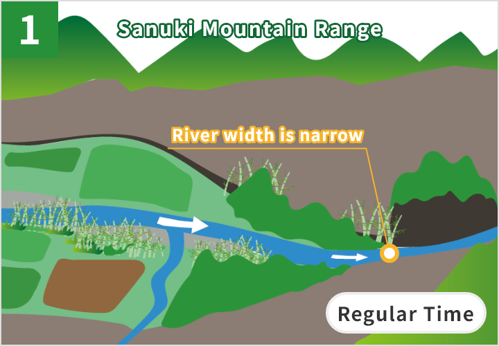
Regular Time
The Yoshinogawa River flows smoothly near Minoda Ohashi Bridge with a regular amount of water.
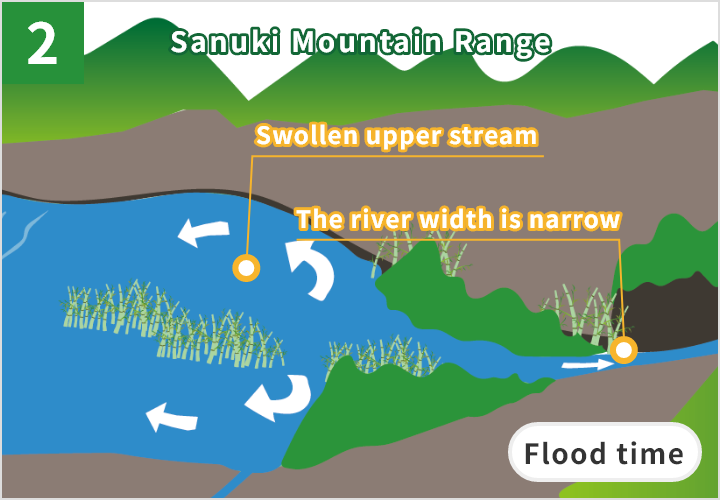
Flood time
Since the river width is narrow around the bridge, only a limited amount of water can flow to downstream. This is why the upper stream of the river easily floods when the river swells.
Let’s all work together to preserve the landscapes and natural environment of the area. Each of us has a responsibility to protect our great Earth. Please do not litter and refrain from taking rocks and plants. Thank you for your cooperation.
*Part of this area is protected by laws and regulations. Please follow the rules to conserve the natural environment.
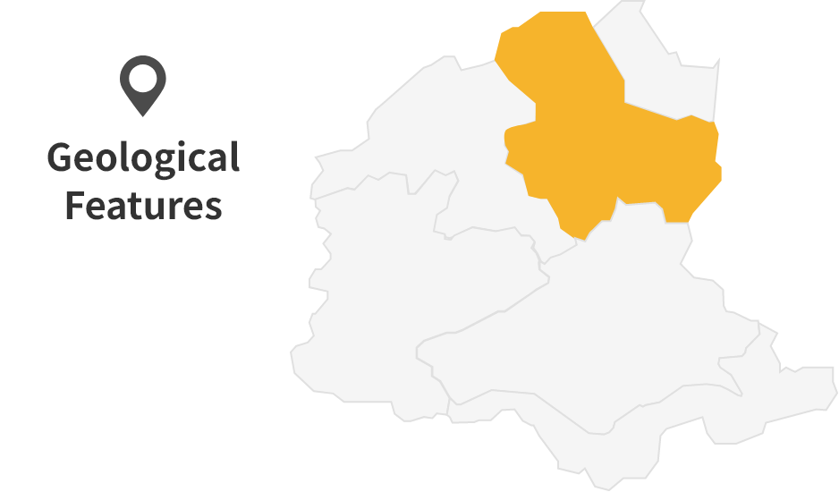
Site List of Ikawa and Higashimiyoshi Town Area
Geosites
Geosites are specific spots where geological features are found and need to be protected.
Syncline Structure in Izumi Group
The Sanuki Mountain Range is mainly made up of layers of sandstone and mudstone. These layers form a large, upside-down arch shape, known as a syncline. The axis of this arch can be seen along the Masukawatani River. These sand and mud layers were originally deposited on the ocean floor about 80 million years ago. As the layers were gradually uplifted, they tilted eastward. This process formed the syncline structure we see today—shaped like the letter "U."
Outcrop of the MTL in Kamo
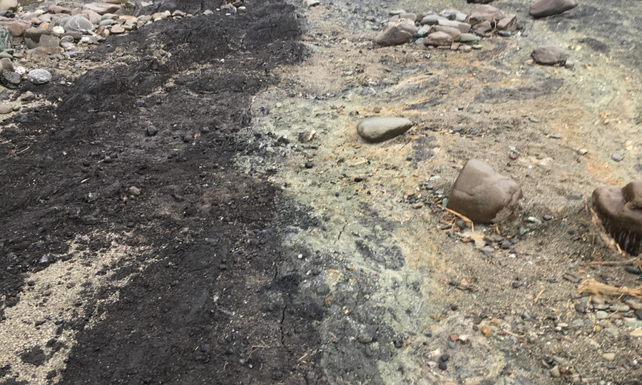
This is an outcrop of the fracture zone of the Ikeda Fault, located along the riverbank in Kamo. It was exposed when heavy rainfall in July 2018 caused flooding in the Yoshinogawa River, washing away rocks along the riverbank. Today, you can see the fracture zone of the Izumi Group (black color), which forms the land north of the MTL, and the fracture zone of the Sambagawa crystalline schist (greenish-gray), which makes up the land to the south.
Cultural Sites
Cultural Sites are specific spots where cultural heritage has been shaped by geological features and need to be protected.
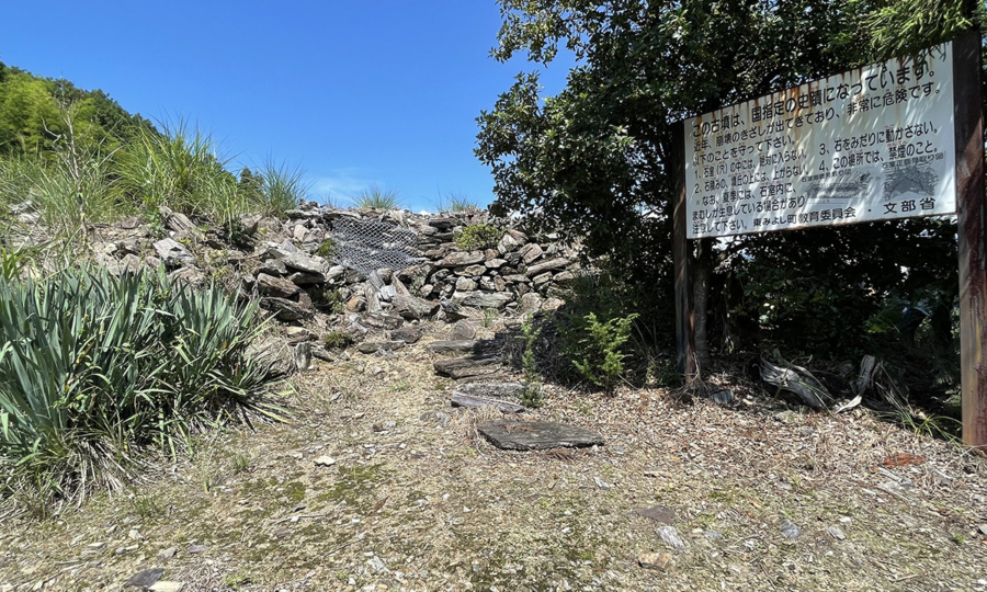
Ruins of Yatsuishi Castle
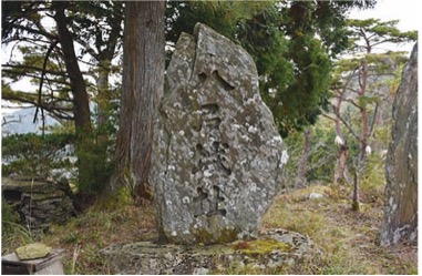
Yatsuishi Castle once stood along the route connecting the Inouchi Area, Shitsukawa Area, and Iya Area. Built on the tip of a mountain ridge at an elevation of around 800 meters, the castle was surrounded by rugged terrain. The remaining stone walls are made from rounded, fist-sized rounded conglomerate rocks.
Kainayama Ranch
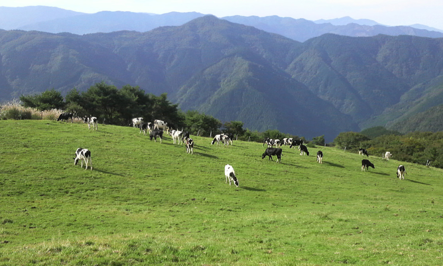
Mt. kaina features a gentle summit and a soft, rolling ridgeline. The landscape is shaped by a linear depression, a long, narrow landform created by past landslides. Thanks to its cool temperatures and mild terrain, the area offers ideal conditions for open grazing during the summer months.
Stream Pool in Minoda
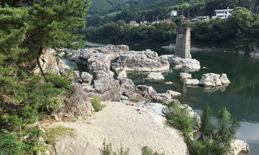
In the Minoda area, the steady flow of the Yoshinogawa River has carved into the riverbed, made of crystalline schist, creating a stream pool. This natural formation stretches about 2 km in length and 100 meters in width. Near the Yoshinogawa Highway Oasis rest area, you will find striking features like large rocks made of psammitic schist. If you look closely near the Minoda Ohashi Bridge, you can also spot outcrops of greenschist in the stream pool.
Ashirohigashibara Ruins
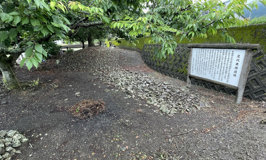
The Ashirohigashibara site features a keyhole-shaped bruial mound and a group of cairns, believed to date back to the 3rd Century AD. During the Yoshinogawa North Riverbank Irrigation Project, which began in 1981, a stone-piled tombs and more than 36 cairns were uncovered across a 180-meter stretch from west to east. These tombs and cairns are made of sandstone breccia sourced from the nearby Sanuki Mountain Range.
Records of Flooding at Amanohashidate Shrine
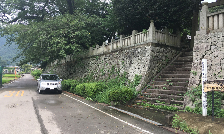
The shrine precinct stands on a fluvial terrace, slightly elevated from the surrounding area. Visitors reach the shrine by climbing a set of steps, one of which marks the height of the river during a major flood caused by 'Typhoon June' in September 1954. Metal studs embedded in the step show how high the water rose, offering a powerful reminder of the typhoon’s impact. The difference in elevation between the town road and the shrine grounds is 4.1 meters.
Giant Camphor Tree in Kamo
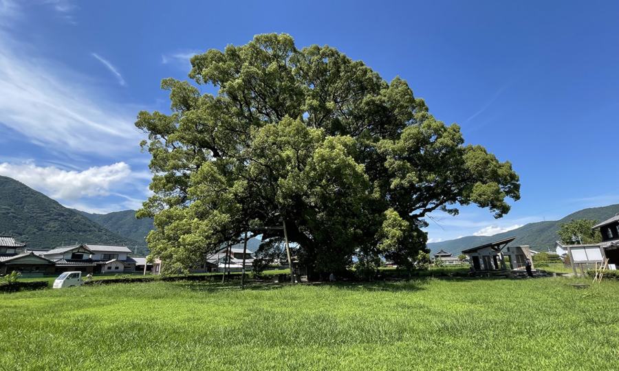
This giant camphor tree (Cinnamomum camphora) stands in the flatlands formed by sediments from the Yoshinogawa River. Its roots stretch around 23 meters in circumference, and its trunk measures about 16 meters around. Estimated to be around 1000 years old, the tree has withstood countless thunderstorms and windstorms over the centuries. With its long, spreading branches, the tree appears to embrace both the sky and the earth. Standing beside it, you can feel its enduring strength and presence.
Tanda Kofun (Ancient Tomb)
Tanda Kofun is located along the trail leading up to Mt. Kamoyama, near the tip of a ridgeline at an elevation of about 320 meters. This stone-piled tomb is constructed from various types of conglomerate, composed of crystalline schist. At the rear of the tomb, a pit chamber has been installed, and its entrance remains open. Inside the chamber, several burial items were discovered, including a bronze mirror, iron swords, and iron axes—typical grave goods from the late 3rd to the end of the 4th century.
Iwakage Ruins in Kamodanigawa River
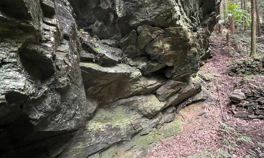
Iwakage Ruins are located along the Kamodanigawa River, where it is believed that hunters once set up camp in ancient times. A massive rock of crystalline schist broke apart and collapsed along its schistosity planes, where the rock naturally splits due to aligned mineral grains. The resulting hollow space was once used as a campsite for hunting.
The site includes a scattering of small ruins across the area, each marked with a number for preservation and study. Artifacts dating back to around 10,000 BC and 1,000 BC have been discovered at Ruins No. 1, 2, and 5.
- HOME
- Miyoshi Geopark Areas
- Ikawa and Higashimiyoshi Town Area